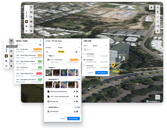
Jobsite Visibility Redefined
Connected Construction Platform: a better way to manage your project with fewer errors, delays, and less rework.


Connected Construction Platform: a better way to manage your project with fewer errors, delays, and less rework.
vSite is a digital twin of your construction site. It combines all relevant project data and places it into its geospatial context to help all stakeholders have instant access to the information, plan better, collaborate more easily, and reduce project delays and rework.
Unify All Data
Find data fast and streamline your work by combining all construction data in one place with location context added.
Gain Visual Clarity
Get deeper insights into project challenges with rich 3D visual context to make smarter project decisions that save time and reduce rework.
Collaborate With Ease
Make it easier for all project members to share and act on-site data, images, and tasks from any jobsite and any device.
Access, manage, and analyze critical project files from a common data source, streamlining project management and efficiency.
Find every project detail and provide full transparency to all stakeholders in full 360 Degree 3D and AR (Augmented Reality).
Receive project updates and assign work packs by centimeter accurate location, making it easier to collaborate with your crew and find location-based data.
Get a better idea of what’s happening on the job with 3D site models created from LIDAR, video, and orientation accurate photos uploaded in seconds.
Provide a dependable reference that is more easily searchable and more rapidly available for future maintenance and compliance.
Ensure compatibility with the tools you already use with support for a wide variety of popular construction software data formats. Full list of supported formats.
Use standard off-the-shelf hardware, including Android phones and tablets, iPhones, iPads and even the futuristic MS HoloLens.
 Autodesk Build
 Bentley iTwin
 Esri ArcGIS
 GeoJSON
 PDF
PDF
 Pix4D
Pix4D
 Civil3D
 .DWG/.DXF
 IFC
IFC
 Navisworks
 Revit
Revit
Site workers use 3D LIDAR scans to capture a trench dig, which is instantly uploaded to vSite for immediate review by off site engineers.
A visual timeline of a water main replacement captured in vSite and vGIS AR to document as-built and work-in-progress.


Adam Horn
Civil Integrated Solutions - Section Leader